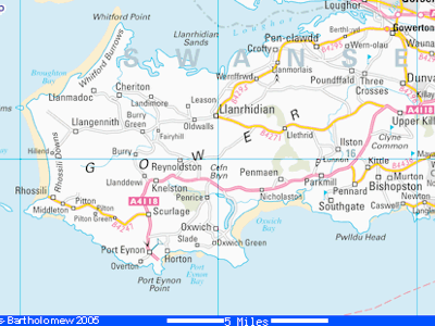
The Gower was the first area in the UK to be designated an area of outstanding natural beauty¹. My geographic knowledge was deficient; I did not hear of the Gower until sharing space with Geoff Roderick in Plymouth. The Gower is a pretty, roughly rectangular peninsula with its long axis ENE - WSW with Swansea on the east-most southern corner. It is easily reached on the M4 [Bristol, Newport, Cardiff, then Swansea]. Swansea Bay is to the south-east, Llanelli to the north across the muddy Loughor estuary. Swansea Bay is marked to the south by The Mumbles and the western end of the rectangle is the touristy bit; a long and gorgeous beach facing west into the waves, so good for surfing, rugged cliffs along a lot of the southern edge.
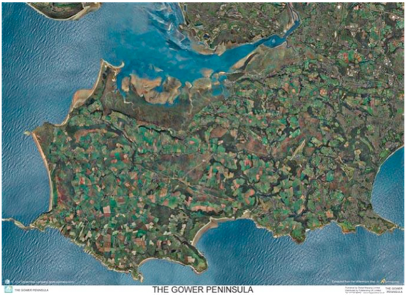
This aerial photo from mapstop.co.uk shows the land use is mostly farming. You can just make out Swansea airport, and the common land is easily seen as larger consistent patches.
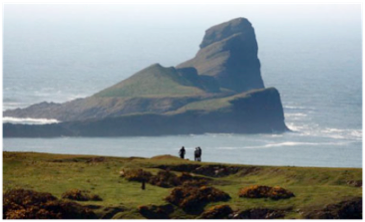
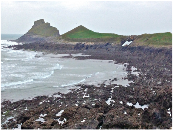
The intriguing point to the west is called Worms Head. The excellent picture above is from the Guardian taken from the east, one from me slightly further south.
The Gower was the first area in the UK to be designated an area of outstanding natural beauty, as I wrote at the top. The rock strata are all stacked vertically pointing a little north, as is demonstrated by the missing slabs forming a hole, and therefore a bridge. This is also what gives both the beaches and the cliffs. Picture showing hillside and beach, taken from the headland over-looking Worms Head. This about mid-tide and the weather was not producing big waves.
Three of us took a trip from Bristol to explore. A brief glance at the map told us that Worms Head was where we would want to go and two hours on a Friday at the end of half-term served to get us there, with lunch on arrival. Since the clocks had already gone back, the pictures show a pleasant day at the end of October. The headland overlooking Worms Head shows us that walking to the head itself is possible at low tide and, as chance would have it today we can access this between 1510 and 2010.
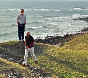
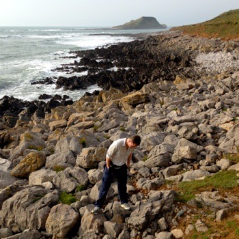
Pic taken by C clearly showing a decision taken to have a go at this later on, judging by the huge grin on Pete’s face. A wander around the coast path to the south gave a flavour of the geography and geology, as evidenced by this pic of Pete looking for things between the rocks. This part of the day was enhanced by meeting a seal very close to shore; not my photo, but from goweros.blogspot. Knowing Cornwall, we soon pick up a feeling of having seen this before and turn inland on a mix of well-explained footpaths, bridleways and farmers’ trackways. C was excited to see a farmer using dogs to herd his sheep and took video to share back home. The process was visibly effective and far more efficient than using merely people. On returning to near the car-park at Rhossili, we turned north to go look at the beckoning hillside above the beach. The vegetation changed dramatically - heather on the exposed bits, bracken on the wet-weather faces, welsh ponies galore quite indifferent to people. We met choughs and saw a kestrel but no buzzards. C had soon had enough of this, getting cold, hungry and thirsty. Descent through the bracken towards the beach proved an interesting challenge and 1510 occurred while doing this. She headed for an ice-cream and the lads hurried off for an appointment with a Welsh Worm, reaching the tide-line around 1545.
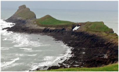
The crossing to the worms has two rough patches; this one and a second between the two visible points of different greens. The dark coloured rock gives good grip where barnacled but very poor grip where smooth. We were late enough - and the day nice enough - for the rock to be dry, but the terrain is sufficiently varied vertically to make for a slow crossing. Pete was on form and we made good speed in rock-hopping, mostly by letting small failures in balance determine where subsequent stepping would be. The pic below shows many things, including people well ahead of us (probably 30 minutes); the bridge is awesome going out and unseen coming back. There are small dark-coloured sheep and evidence that the rocks are largely uncrossable for animals came in the form of a recently dead cow on the second stretch of rocks. To our surprise the very flat-looking spine shown as skyline above was not as scarily narrow as it looks from the mainland and the slab of rock at the very tip quite accessible (though I’d not want to attempt this crossing with snow anywhere). The wind was strong, the sun fading and we unconsciously knew to hurry. Which we did, exhibiting competitive spirit which is not appropriate over such ground. Indeed, I did an exhibition fall on an easy bit, due in part to concentrating on the other guys we were overtaking, not where I was going. Prat-fall, but one with consequences². We reached the carpark at 1745 and, after a brief wash each, got in the car to drive home, still before 1800 [and my turn to drive]. At this point we were in the dark, so everyone we had passed on the trip back was now still walking, struggling with a rising tide, poor visibility and treacherous ground. We would be challenged to do the trip out and back much faster, and though better light and far better balance would help me, a five-minute improvement would take a deal of specific training (and would be pretty pointless, don’t you think?).
As a day out, realistically an afternoon on the ground, and I think we did pretty thorough exploration. Coast path, moorland, beach, rocky shores and a gallop against the tide; great. Good company, good lunch and, by dropping the others off at the pub back in Bristol and trotting across the valley back to join them after parking the car, more good food and some beer to finish. Excellent.
DJS 20141109
Unused research, so genuinely more at http://www.geographical.co.uk/Magazine/UK_Landscapes/Gower_-_Dec_2006.html
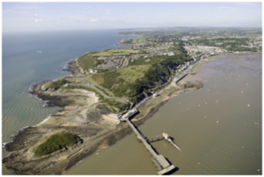
Top picture (map) from cottageingower and Colllins-Batholemew. The aerial of the Mumbles below is taken from beacheswestwales.
Most photos were taken by myself or Cynthia, on her iPhone5.
1 1956, under the National Parks and access to the Countryside Act 1949, extended by the CRoW Act in 2000. Refer to the National Planning Policy Framework 2012 for relative importance in planning issues. There are [2013] 46 AONBs; the older ones are: 1958, Northumberland coast,; 1959, 27% of Cornwall; South Devon [1960], 2000km2 of the Cotswolds [1966. Not to be confused with National Parks. 13 in England and Wales, which are somehow a step up in leave-me-alone status. I note here that the AONB website won’t load on a Sunday morning, so i can list AONBs, but I can’t put them in chronological order.
2 Ah, but the consequences: my spectacular roll on rough ground produced deep bruising on the left leg between knee and ankle. By bedtime that day the leg had swollen enough to make my trousers a tight fit. Since I was moving easily all day I hadn’t even noticed until after the second beer. Over the next week the bruising did some spectacular colour jobs on my leg, only a little black but swollen and coloured over the whole of the calf area on the outer side from the shin bone to rear midline. I remember thinking at the time that I’d rolled well with the loss of balance (concentration, old age, silly bugger) but the extent of the damage remains a surprise. The colour scheme has varied each day, presumably as the bruising works its way out, including some very red patches below the knee-cap for a day; the swelling has slowly diminished but remains surprisingly uniform; at its worst the leg was about an inch larger in radius. Writing this ten days later the skin has faded to a uniform yellow [Me a little Chinee] and pains me most during the later part of the day (probably because I’ve been sat or active, so the leg has a head of blood supply to add pressure). I take no notice of the (googled) medical advice to rest, since (i) clearly nothing is broken (ii) exercise does not hurt (iii) once moving, any pain disappears. I ran every second day, including racing on Saturday (if slowly, almost 21 mins for 5km). Rest, I agree with Dick Francis, will perhaps have less pain but will make mending slower; worse, the lack of exercise will slow the results for the races later this month. A little pain should be a good thing. So I tell myself. You may disagree. I thought to add pics of the leg, but looked at bruising on Google images. Mine is nothing by comparison.
